 ATLANTIC TSUBAKI
Current Status
Where is the vessel?
ATLANTIC TSUBAKI is currently in 44 nm NE of Tepanje, based on AIS data received about 14h ago.
Latest AIS update:
Current position: 46.75590° N, 154.24036° E (44 nm NE of Tepanje)
Average speed (last 7 days): Loading…
Average speed (last 30 days): Loading…
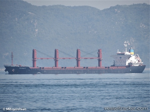
Vessel profile: ATLANTIC TSUBAKI is a Bulk Carrier with dimensions 169m x 27m.
This page combines live AIS, route history, probable destination signals, nearby traffic, and port activity for practical vessel monitoring.
The current position of vessel ATLANTIC TSUBAKI is 46.75590 lat / 154.24036 lng. Updated: 2026-05-20 00:12:59 UTCCurrently sailing under the flag of Singapore ![]()
ATLANTIC TSUBAKI built in 2015 year
Deadweight:
28316 tDetails:
Live Vessel ATLANTIC TSUBAKI Analytics (details, animations, etc.)
Recent AIS points (UTC):
2026-05-19 19:29:20 UTC · 47.25001, 155.39896 · SOG 10.4 kn · COG 243°2026-05-19 22:13:09 UTC · 46.97344, 154.74167 · SOG 11.7 kn · COG 241°
2026-05-19 22:25:21 UTC · 46.95151, 154.69360 · SOG 11.7 kn · COG 239°
2026-05-20 00:12:59 UTC · 46.75590, 154.24036 · SOG 12.3 kn · COG 237°