 vesseltracker.com
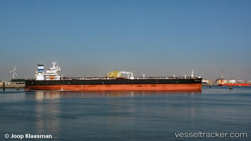
 VST OCEANIA
Current Status
Where is the vessel?
VST OCEANIA is currently in 39 nm N of Muda Marine Terminal, based on AIS data received about 14h ago.
Latest AIS update:
Current position: 8.18667° N, 103.20333° E (39 nm N of Muda Marine Terminal)
Average speed (last 7 days): Loading…
Average speed (last 30 days): Loading…
Vessel profile: VST OCEANIA is a Tanker with dimensions m x m.
This page combines live AIS, route history, probable destination signals, nearby traffic, and port activity for practical vessel monitoring.
The current position of vessel VST OCEANIA is 8.18667 lat / 103.20333 lng. Updated: 2026-05-18 06:53:51 UTCNearest reference points:
- 23 nm E of Muda Marine Terminal
- Near Muda Marine Terminal
- 30 nm E of Dai Hung (STS Load)
Currently sailing under the flag of Panama ![]()
Details:
Live Vessel VST OCEANIA Analytics (details, animations, etc.)
Recent AIS points (UTC):
2026-05-18 03:23:52 UTC · 8.82333, 102.98333 · SOG 10 kn · COG -1°2026-05-18 04:15:11 UTC · 8.68520, 103.04032 · SOG 10.4 kn · COG 170°
2026-05-18 05:34:11 UTC · 8.44585, 103.11243 · SOG 12.3 kn · COG 163°
2026-05-18 06:53:51 UTC · 8.18667, 103.20333 · SOG 12 kn · COG -1°