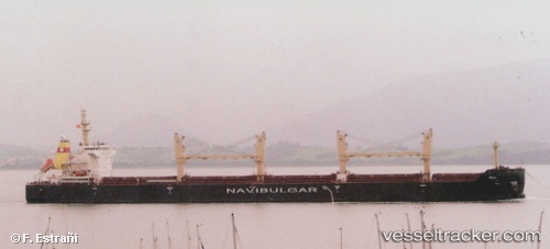
 Rila
Rila
Current Status
Where is the vessel?
Rila is currently in 14 nm E of Waterport, based on AIS data received about 14h ago.
Latest AIS update:
Current position: 36.05355° N, 5.07539° W (14 nm E of Waterport)
Average speed (last 7 days): Loading…
Average speed (last 30 days): Loading…
Vessel profile: Rila is a Bulk Carrier with dimensions 185m x 31m.
This page combines live AIS, route history, probable destination signals, nearby traffic, and port activity for practical vessel monitoring.
The current position of vessel Rila is 36.05355 lat / -5.07539 lng. Updated: 2026-06-22 18:12:55 UTCNearest reference points:
- Near Waterport
- Near Sotogrande
- Near La Línea de la Concepción
Currently sailing under the flag of Malta ![]()
Details:
Live Vessel Rila Analytics (details, animations, etc.)
Recent AIS points (UTC):
2026-06-22 13:57:04 UTC · 35.92888, -5.62834 · SOG 9.7 kn · COG 82°2026-06-22 15:47:15 UTC · 36.03368, -5.26236 · SOG 11 kn · COG 68°
2026-06-22 17:09:46 UTC · 36.10277, -5.23971 · SOG 0.5 kn · COG 148°
2026-06-22 18:12:55 UTC · 36.05355, -5.07539 · SOG 10.6 kn · COG 115°