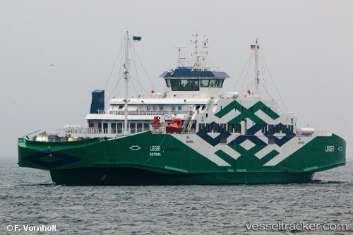
Leiger
Current StatusWhere is the vessel?
Leiger is currently in Near Sviby, based on AIS data received about 14h ago.
Latest AIS update:
Current position: 58.89869° N, 23.27520° E (Near Sviby)
Average speed (last 7 days): Loading…
Average speed (last 30 days): Loading…
Vessel profile: Leiger is a Passenger Ro Ro Cargo Ship with dimensions 20m x 114m.
This page combines live AIS, route history, probable destination signals, nearby traffic, and port activity for practical vessel monitoring.
The current position of vessel Leiger is 58.89869 lat / 23.27520 lng. Updated: 2026-05-20 19:32:07 UTCNearest reference points:
- Near Ristna
- Near Mahu Sadam
- Near Tvärminne
Details:
Live Vessel Leiger Analytics (details, animations, etc.)
Recent AIS points (UTC):
2026-05-20 15:53:58 UTC · 58.90695, 23.42199 · SOG 0 kn · COG 317°2026-05-20 16:15:07 UTC · 58.90784, 23.35406 · SOG 9.5 kn · COG 269°
2026-05-20 18:05:19 UTC · 58.89195, 23.22083 · SOG 10.2 kn · COG 70°
2026-05-20 19:32:07 UTC · 58.89869, 23.27520 · SOG 10.4 kn · COG 252°