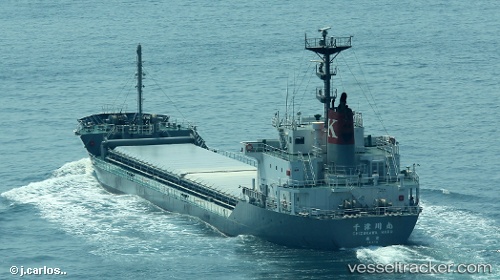
 Chizukawa Maru
Current Status
Where is the vessel?
Chizukawa Maru is currently in Near MIZUSHIMA, based on AIS data received about 15h ago.
Latest AIS update:
Current position: 34.43736° N, 133.68649° E (Near MIZUSHIMA)
Average speed (last 7 days): Loading…
Average speed (last 30 days): Loading…
Vessel profile: Chizukawa Maru is a Limestone Carrier with dimensions 106m x 17m.
This page combines live AIS, route history, probable destination signals, nearby traffic, and port activity for practical vessel monitoring.
The current position of vessel Chizukawa Maru is 34.43736 lat / 133.68649 lng. Updated: 2026-06-06 13:51:26 UTCNearest reference points:
- Near MIZUSHIMA
- Near Kurashiki
- Near FUKUYAMA
Currently sailing under the flag of Japan ![]()
Details:
Live Vessel Chizukawa Maru Analytics (details, animations, etc.)
Recent AIS points (UTC):
2026-06-06 10:55:36 UTC · 34.49477, 133.72466 · SOG 0 kn · COG 291°2026-06-06 12:01:36 UTC · 34.49477, 133.72462 · SOG 0 kn · COG 291°
2026-06-06 13:47:33 UTC · 34.43646, 133.70522 · SOG 14.5 kn · COG 265°
2026-06-06 13:51:26 UTC · 34.43736, 133.68649 · SOG 14.5 kn · COG 277°