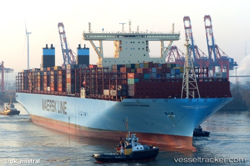
Manchester Maersk
Current StatusWhere is the vessel?
Manchester Maersk is currently in 143 nm SW of Xijiang, based on AIS data received about 15h ago.
Latest AIS update:
Current position: 19.25207° N, 113.52698° E (143 nm SW of Xijiang)
Average speed (last 7 days): Loading…
Average speed (last 30 days): Loading…
Vessel profile: Manchester Maersk is a Container Ship with dimensions 58m x 399m.
This page combines live AIS, route history, probable destination signals, nearby traffic, and port activity for practical vessel monitoring.
The current position of vessel Manchester Maersk is 19.25207 lat / 113.52698 lng. Updated: 2026-07-16 07:21:21 UTCNearest reference points:
- 123 nm S of Shadi
- 78 nm SW of Xijiang
- 60 nm SE of Shadi
Details:
Live Vessel Manchester Maersk Analytics (details, animations, etc.)
Recent AIS points (UTC):
2026-07-16 03:54:43 UTC · 18.72667, 113.49833 · SOG 10 kn · COG -1°2026-07-16 04:53:59 UTC · 18.89622, 113.50410 · SOG 10.6 kn · COG 4°
2026-07-16 05:39:01 UTC · 19.03008, 113.51133 · SOG 10.8 kn · COG 5°
2026-07-16 07:21:21 UTC · 19.25207, 113.52698 · SOG 7.1 kn · COG 3°