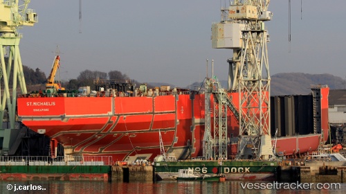
 St.michaelis
Current Status
Where is the vessel?
St.michaelis is currently in Near Yokkaichi, based on AIS data received about 14h ago.
Latest AIS update:
Current position: 34.90334° N, 136.73866° E (Near Yokkaichi)
Average speed (last 7 days): Loading…
Average speed (last 30 days): Loading…
Vessel profile: St.michaelis is a Chemical Oil Products Tanker with dimensions 181m x 32m.
This page combines live AIS, route history, probable destination signals, nearby traffic, and port activity for practical vessel monitoring.
The current position of vessel St.michaelis is 34.90334 lat / 136.73866 lng. Updated: 2026-05-22 18:00:14 UTCNearest reference points:
- Near Yokkaichi
- Near Nagoya
- Near Kinuura
Currently sailing under the flag of Singapore ![]()
Details:
Live Vessel St.michaelis Analytics (details, animations, etc.)
Recent AIS points (UTC):
2026-05-22 14:14:30 UTC · 34.90366, 136.73938 · SOG 0 kn · COG 164°2026-05-22 16:18:00 UTC · 34.90355, 136.73903 · SOG 0.1 kn · COG 149°
2026-05-22 16:45:54 UTC · 34.90367, 136.73930 · SOG 0.1 kn · COG 155°
2026-05-22 18:00:14 UTC · 34.90334, 136.73866 · SOG 0.2 kn · COG 137°