Persepolis
Current StatusWhere is the vessel?
Persepolis is currently in 13 nm S of Hettimulla, based on AIS data received about 15h ago.
Latest AIS update:
Current position: 7.06987° N, 80.01086° W (13 nm S of Hettimulla)
Average speed (last 7 days): Loading…
Average speed (last 30 days): Loading…
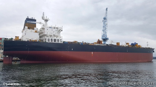
Vessel profile: Persepolis is a Crude Oil Tanker with dimensions 32m x 228m.
This page combines live AIS, route history, probable destination signals, nearby traffic, and port activity for practical vessel monitoring.
The current position of vessel Persepolis is 7.06987 lat / -80.01086 lng. Updated: 2026-05-21 04:11:11 UTCNearest reference points:
- 30 nm E of El Cirial (Isla Iguana)
- 20 nm S of El Puerto
- Near Saboga
Details:
Live Vessel Persepolis Analytics (details, animations, etc.)
Recent AIS points (UTC):
2026-05-21 01:57:52 UTC · 6.87780, -80.36870 · SOG 11.7 kn · COG 89°2026-05-21 02:14:49 UTC · 6.87615, -80.31362 · SOG 11.7 kn · COG 89°
2026-05-21 03:42:54 UTC · 7.00360, -80.07507 · SOG 11.6 kn · COG 46°
2026-05-21 04:11:11 UTC · 7.06987, -80.01086 · SOG 11.5 kn · COG 46°