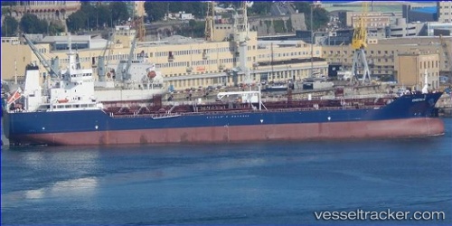
 Greta K
Current Status
Where is the vessel?
Greta K is currently in Near de Ruyter, based on AIS data received about 14h ago.
Latest AIS update:
Current position: 52.44579° N, 4.02628° E (Near de Ruyter)
Average speed (last 7 days): Loading…
Average speed (last 30 days): Loading…
Vessel profile: Greta K is a Chemical Oil Products Tanker with dimensions 158m x 26m.
This page combines live AIS, route history, probable destination signals, nearby traffic, and port activity for practical vessel monitoring.
The current position of vessel Greta K is 52.44579 lat / 4.02628 lng. Updated: 2026-05-20 08:03:57 UTCNearest reference points:
- Near de Ruyter
- 22 nm W of Schoorl
- 23 nm N of de Ruyter
Currently sailing under the flag of Malta ![]()
Details:
Live Vessel Greta K Analytics (details, animations, etc.)
Recent AIS points (UTC):
2026-05-20 04:42:55 UTC · 52.44613, 4.02562 · SOG 0.6 kn · COG 202°2026-05-20 06:03:56 UTC · 52.44610, 4.02574 · SOG 0.3 kn · COG 218°
2026-05-20 07:39:58 UTC · 52.44584, 4.02624 · SOG 0.2 kn · COG 230°
2026-05-20 08:03:57 UTC · 52.44579, 4.02628 · SOG 0.7 kn · COG 231°