 KISOGAWA
Current Status
Where is the vessel?
KISOGAWA is currently in 10 nm NW of SUNGAI UDANG, based on AIS data received about 14h ago.
Latest AIS update:
Current position: 2.32082° N, 101.97866° E (10 nm NW of SUNGAI UDANG)
Average speed (last 7 days): Loading…
Average speed (last 30 days): Loading…
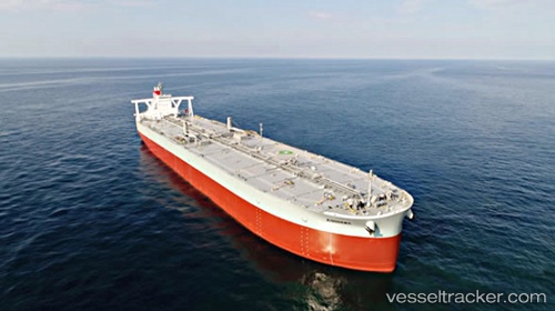
Vessel profile: KISOGAWA is a Crude Oil Tanker with dimensions 340m x 340m.
This page combines live AIS, route history, probable destination signals, nearby traffic, and port activity for practical vessel monitoring.
The current position of vessel KISOGAWA is 2.32082 lat / 101.97866 lng. Updated: 2026-05-19 19:17:55 UTCNearest reference points:
- Near SUNGAI UDANG
- 14 nm W of SUNGAI UDANG
- Near Malacca
Currently sailing under the flag of Japan ![]()
KISOGAWA built in 2017 year
Deadweight:
311831 tDetails:
Live Vessel KISOGAWA Analytics (details, animations, etc.)
Recent AIS points (UTC):
2026-05-19 15:27:24 UTC · 2.31816, 101.98595 · SOG 0 kn · COG -1°2026-05-19 16:52:20 UTC · 2.31695, 101.98327 · SOG 0.5 kn · COG -1°
2026-05-19 18:07:27 UTC · 2.32082, 101.97866 · SOG 0.1 kn · COG -1°
2026-05-19 19:17:55 UTC · 2.32082, 101.97866 · SOG 0.1 kn · COG -1°