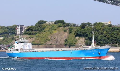
 Hayato
Current Status
Where is the vessel?
Hayato is currently in Near FUKABORI, based on AIS data received about 14h ago.
Latest AIS update:
Current position: 32.69384° N, 129.82172° E (Near FUKABORI)
Average speed (last 7 days): Loading…
Average speed (last 30 days): Loading…
Vessel profile: Hayato is a General Cargo Ship with dimensions 76m x 12m.
This page combines live AIS, route history, probable destination signals, nearby traffic, and port activity for practical vessel monitoring.
The current position of vessel Hayato is 32.69384 lat / 129.82172 lng. Updated: 2026-05-21 07:12:59 UTCNearest reference points:
- Near FUKABORI
- Near MATSUSHIMA
- Near Fukushima, Nagasaki
Currently sailing under the flag of Japan ![]()
Details:
Live Vessel Hayato Analytics (details, animations, etc.)
Recent AIS points (UTC):
2026-05-21 03:37:00 UTC · 32.69382, 129.82172 · SOG 0 kn · COG -1°2026-05-21 04:03:59 UTC · 32.69383, 129.82172 · SOG 0 kn · COG -1°
2026-05-21 05:42:59 UTC · 32.69384, 129.82170 · SOG 0 kn · COG -1°
2026-05-21 07:12:59 UTC · 32.69384, 129.82172 · SOG 0 kn · COG -1°