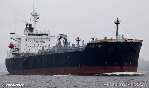
 Lucky Lady
Current Status
Where is the vessel?
Lucky Lady is currently in 12 nm NE of KEA, based on AIS data received about 14h ago.
Latest AIS update:
Current position: 37.82413° N, 24.45087° E (12 nm NE of KEA)
Average speed (last 7 days): Loading…
Average speed (last 30 days): Loading…
Vessel profile: Lucky Lady is a Chemical Oil Products Tanker with dimensions 176m x 31m.
This page combines live AIS, route history, probable destination signals, nearby traffic, and port activity for practical vessel monitoring.
The current position of vessel Lucky Lady is 37.82413 lat / 24.45087 lng. Updated: 2026-05-22 19:58:47 UTCNearest reference points:
- Near Kéa (Tzia)
- Near LAVRIO
- Near LAVRIO MARINA
Currently sailing under the flag of Malta ![]()
Lucky Lady built in 2005 year
Deadweight:
37432 tDetails:
Live Vessel Lucky Lady Analytics (details, animations, etc.)
Recent AIS points (UTC):
2026-05-22 16:14:03 UTC · 37.24556, 24.11750 · SOG 10.2 kn · COG 11°2026-05-22 18:04:45 UTC · 37.56406, 24.19234 · SOG 10.5 kn · COG 11°
2026-05-22 19:50:48 UTC · 37.81160, 24.42578 · SOG 10.5 kn · COG 59°
2026-05-22 19:58:47 UTC · 37.82413, 24.45087 · SOG 10.6 kn · COG 59°