 Karakartal
Current Status
Where is the vessel?
Karakartal is currently in Near GEMLIK, based on AIS data received about 14h ago.
Latest AIS update:
Current position: 40.44582° N, 29.10547° E (Near GEMLIK)
Average speed (last 7 days): Loading…
Average speed (last 30 days): Loading…
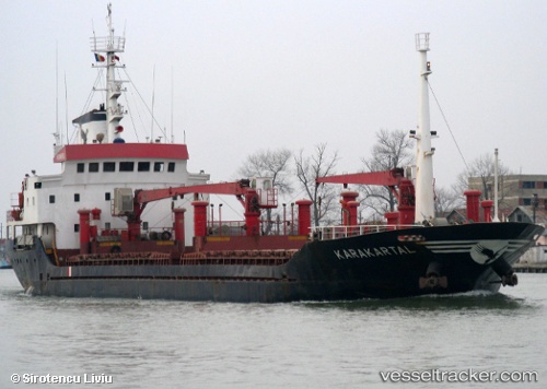
Vessel profile: Karakartal is a General Cargo Ship with dimensions 87m x 13m.
This page combines live AIS, route history, probable destination signals, nearby traffic, and port activity for practical vessel monitoring.
The current position of vessel Karakartal is 40.44582 lat / 29.10547 lng. Updated: 2026-05-19 10:10:34 UTCNearest reference points:
- Near GEMLIK
- 11 nm S of Maltepe
- 14 nm SW of Maltepe
Currently sailing under the flag of Turkey ![]()
Karakartal built in 1994 year
Deadweight:
3325 tDetails:
Live Vessel Karakartal Analytics (details, animations, etc.)
Recent AIS points (UTC):
2026-05-19 07:01:35 UTC · 40.44508, 29.10787 · SOG 0 kn · COG 305°2026-05-19 08:19:32 UTC · 40.44622, 29.10571 · SOG 0 kn · COG 133°
2026-05-19 10:07:35 UTC · 40.44586, 29.10538 · SOG 0 kn · COG 109°
2026-05-19 10:10:34 UTC · 40.44582, 29.10547 · SOG 0.1 kn · COG 104°