 NEW AMSTERDAM
Current Status
Where is the vessel?
NEW AMSTERDAM is currently in 34 nm SW of Ile D’Ouessant, based on AIS data received about 14h ago.
Latest AIS update:
Current position: 48.30819° N, 6.16123° W (34 nm SW of Ile D’Ouessant)
Average speed (last 7 days): Loading…
Average speed (last 30 days): Loading…
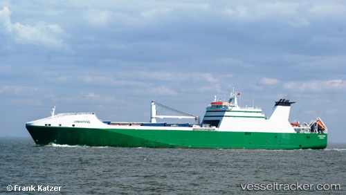
Vessel profile: NEW AMSTERDAM is a Ro-Ro Cargo Ship with dimensions 193m x 26m.
This page combines live AIS, route history, probable destination signals, nearby traffic, and port activity for practical vessel monitoring.
The current position of vessel NEW AMSTERDAM is 48.30819 lat / -6.16123 lng. Updated: 2026-05-21 07:54:02 UTCNearest reference points:
- 35 nm SW of Ile D’Ouessant
- 16 nm NW of Ile D’Ouessant
- 46 nm W of SEIN
Currently sailing under the flag of Netherlands ![]()
NEW AMSTERDAM built in 2003 year
Deadweight:
13274 tDetails:
Live Vessel NEW AMSTERDAM Analytics (details, animations, etc.)
Recent AIS points (UTC):
2026-05-21 04:11:30 UTC · 48.93022, -5.71720 · SOG 11.5 kn · COG 231°2026-05-21 06:11:31 UTC · 48.61221, -5.99610 · SOG 11 kn · COG 205°
2026-05-21 07:04:00 UTC · 48.46221, -6.08608 · SOG 11.2 kn · COG 199°
2026-05-21 07:54:02 UTC · 48.30819, -6.16123 · SOG 12 kn · COG 198°