 IMPERIAL
Current Status
Where is the vessel?
IMPERIAL is currently in 14 nm E of MOOLOOLABA, based on AIS data received about 15h ago.
Latest AIS update:
Current position: 26.68712° S, 153.39108° E (14 nm E of MOOLOOLABA)
Average speed (last 7 days): Loading…
Average speed (last 30 days): Loading…
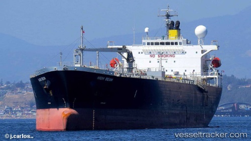
Vessel profile: IMPERIAL is a Oil Products Tanker with dimensions 180m x 32m.
This page combines live AIS, route history, probable destination signals, nearby traffic, and port activity for practical vessel monitoring.
The current position of vessel IMPERIAL is -26.68712 lat / 153.39108 lng. Updated: 2026-05-18 22:08:10 UTCNearest reference points:
- Near MOOLOOLABA
- Near Minyama
- Near NOOSAVILLE
Currently sailing under the flag of Liberia ![]()
IMPERIAL built in 2009 year
Deadweight:
46646 tDetails:
Live Vessel IMPERIAL Analytics (details, animations, etc.)
Recent AIS points (UTC):
2026-05-18 19:09:08 UTC · -26.68667, 153.39000 · SOG 0 kn · COG -1°2026-05-18 19:21:14 UTC · -26.68500, 153.39000 · SOG 0 kn · COG -1°
2026-05-18 21:50:10 UTC · -26.68693, 153.39105 · SOG 0.5 kn · COG 46°
2026-05-18 22:08:10 UTC · -26.68712, 153.39108 · SOG 0.4 kn · COG 40°