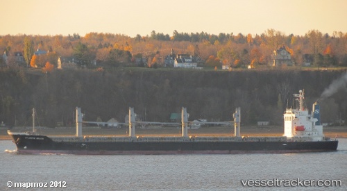
 LUNARA
Current Status
Where is the vessel?
LUNARA is currently in 20 nm SE of Sulina (Port et Zone Franche), based on AIS data received about 15h ago.
Latest AIS update:
Current position: 44.98315° N, 30.06769° E (20 nm SE of Sulina (Port et Zone Franche))
Average speed (last 7 days): Loading…
Average speed (last 30 days): Loading…
Vessel profile: LUNARA is a General Cargo Ship with dimensions 28m x 180m.
This page combines live AIS, route history, probable destination signals, nearby traffic, and port activity for practical vessel monitoring.
The current position of vessel LUNARA is 44.98315 lat / 30.06769 lng. Updated: 2026-05-22 18:56:19 UTCNearest reference points:
- 13 nm E of Sulina (Port et Zone Franche)
- 12 nm SE of Sulina (Port et Zone Franche)
- Near Ust-Dunaisk/Vylkove
Currently sailing under the flag of Barbados ![]()
LUNARA built in 2010 year
Deadweight:
33709 tDetails:
Live Vessel LUNARA Analytics (details, animations, etc.)
Recent AIS points (UTC):
2026-05-22 16:13:41 UTC · 44.98155, 30.06424 · SOG 0.2 kn · COG 59°2026-05-22 18:03:12 UTC · 44.98311, 30.06779 · SOG 0 kn · COG 232°
2026-05-22 18:56:19 UTC · 44.98315, 30.06769 · SOG 1.3 kn · COG 223°
2026-05-22 18:56:19 UTC · 44.98315, 30.06769 · SOG 1.3 kn · COG 223°