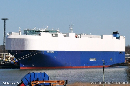
 VIKING ADVENTURE
Current Status
Where is the vessel?
VIKING ADVENTURE is currently in 39 nm E of Lucinda, based on AIS data received about 15h ago.
Latest AIS update:
Current position: 18.32333° S, 146.99167° E (39 nm E of Lucinda)
Average speed (last 7 days): Loading…
Average speed (last 30 days): Loading…
Vessel profile: VIKING ADVENTURE is a Vehicles Carrier with dimensions 199m x 32m.
This page combines live AIS, route history, probable destination signals, nearby traffic, and port activity for practical vessel monitoring.
The current position of vessel VIKING ADVENTURE is -18.32333 lat / 146.99167 lng. Updated: 2026-05-19 16:28:14 UTCNearest reference points:
- Near Townsville
- Near CAIRNS
- Near AIRLIE
Currently sailing under the flag of Marshall Islands ![]()
VIKING ADVENTURE built in 2015 year
Deadweight:
18372 tDetails:
Live Vessel VIKING ADVENTURE Analytics (details, animations, etc.)
Recent AIS points (UTC):
2026-05-19 13:49:10 UTC · -17.70500, 147.24333 · SOG 15 kn · COG -1°2026-05-19 13:51:23 UTC · -17.71430, 147.24193 · SOG 15.2 kn · COG 192°
2026-05-19 15:37:14 UTC · -18.16167, 147.13834 · SOG 15 kn · COG -1°
2026-05-19 16:28:14 UTC · -18.32333, 146.99167 · SOG 15 kn · COG -1°