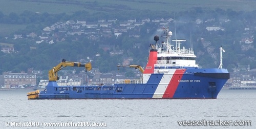
 Kingdom Of Fife
Current Status
Where is the vessel?
Kingdom Of Fife is currently in Near Middlesbrough, based on AIS data received about 15h ago.
Latest AIS update:
Current position: 54.58044° N, 1.21612° W (Near Middlesbrough)
Average speed (last 7 days): Loading…
Average speed (last 30 days): Loading…
Vessel profile: Kingdom Of Fife is a Offshore Tug Supply Ship with dimensions 60m x 14m.
This page combines live AIS, route history, probable destination signals, nearby traffic, and port activity for practical vessel monitoring.
The current position of vessel Kingdom Of Fife is 54.58044 lat / -1.21612 lng. Updated: 2026-05-24 13:20:22 UTCNearest reference points:
- Near TYNE
- Near Blyth
- Near Hessle/Hull
Currently sailing under the flag of United Kingdom ![]()
Kingdom Of Fife built in 2008 year
Deadweight:
1200 tDetails:
Live Vessel Kingdom Of Fife Analytics (details, animations, etc.)
Recent AIS points (UTC):
2026-05-24 10:11:21 UTC · 54.58036, -1.21607 · SOG 0 kn · COG 256°2026-05-24 12:23:30 UTC · 54.58044, -1.21612 · SOG 0 kn · COG 255°
2026-05-24 13:17:24 UTC · 54.58044, -1.21612 · SOG 0 kn · COG 255°
2026-05-24 13:20:22 UTC · 54.58044, -1.21612 · SOG 0 kn · COG -1°