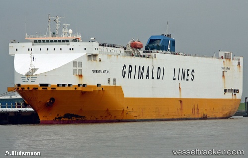
 Grande Europa
Current Status
Where is the vessel?
Grande Europa is currently in Near Verrebroek, based on AIS data received about 14h ago.
Latest AIS update:
Current position: 51.27985° N, 4.22085° E (Near Verrebroek)
Average speed (last 7 days): Loading…
Average speed (last 30 days): Loading…
Vessel profile: Grande Europa is a Vehicles Carrier with dimensions 183m x 32m.
This page combines live AIS, route history, probable destination signals, nearby traffic, and port activity for practical vessel monitoring.
The current position of vessel Grande Europa is 51.27985 lat / 4.22085 lng. Updated: 2026-05-20 09:40:54 UTCNearest reference points:
- Near Verrebroek
- Near Doel
- Near Kallo
Currently sailing under the flag of Italy ![]()
Grande Europa built in 1998 year
Deadweight:
18461 tDetails:
Live Vessel Grande Europa Analytics (details, animations, etc.)
Recent AIS points (UTC):
2026-05-20 06:04:55 UTC · 51.27981, 4.22085 · SOG 0 kn · COG 218°2026-05-20 07:43:55 UTC · 51.27985, 4.22084 · SOG 0 kn · COG 218°
2026-05-20 08:05:02 UTC · 51.27984, 4.22086 · SOG 0 kn · COG 218°
2026-05-20 09:40:54 UTC · 51.27985, 4.22085 · SOG 0 kn · COG 218°