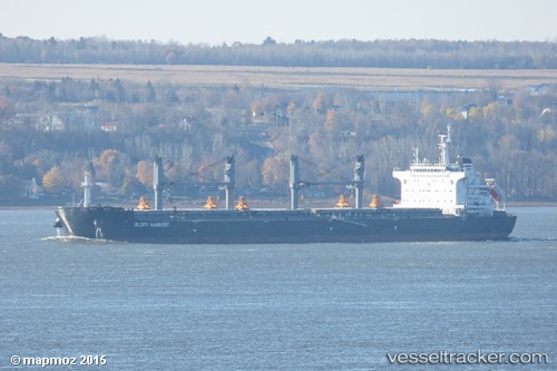
 Glory Harvest
Current Status
Where is the vessel?
Glory Harvest is currently in Near Pinto Island, based on AIS data received about 14h ago.
Latest AIS update:
Current position: 30.67060° N, 88.03089° W (Near Pinto Island)
Average speed (last 7 days): Loading…
Average speed (last 30 days): Loading…
Vessel profile: Glory Harvest is a Bulk Carrier with dimensions 199m x 32m.
This page combines live AIS, route history, probable destination signals, nearby traffic, and port activity for practical vessel monitoring.
The current position of vessel Glory Harvest is 30.67060 lat / -88.03089 lng. Updated: 2026-06-04 02:47:49 UTCNearest reference points:
- Near Pinto Island
- Near Mobile
- Near Chickasaw
Currently sailing under the flag of Marshall Is ![]()
Details:
Live Vessel Glory Harvest Analytics (details, animations, etc.)
Recent AIS points (UTC):
2026-06-03 22:32:49 UTC · 30.67048, -88.03079 · SOG 0 kn · COG 154°2026-06-03 23:23:49 UTC · 30.67066, -88.03094 · SOG 0 kn · COG 154°
2026-06-04 02:17:49 UTC · 30.67066, -88.03096 · SOG 0 kn · COG 154°
2026-06-04 02:47:49 UTC · 30.67060, -88.03089 · SOG 0 kn · COG 154°