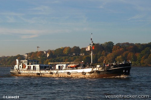
 Kathi
Kathi
Current Status
Where is the vessel?
Kathi is currently in Near Altenwerder, based on AIS data received about 14h ago.
Latest AIS update:
Current position: 53.51440° N, 9.93366° E (Near Altenwerder)
Average speed (last 7 days): Loading…
Average speed (last 30 days): Loading…
Vessel profile: Kathi is a Service Ship with dimensions 43m x 7m.
This page combines live AIS, route history, probable destination signals, nearby traffic, and port activity for practical vessel monitoring.
The current position of vessel Kathi is 53.51440 lat / 9.93366 lng. Updated: 2026-05-25 13:34:51 UTCNearest reference points:
- Near Bahrenfeld
- Near Hamburg-Mitte
- Near Allermöhe
Currently sailing under the flag of Germany ![]()
Kathi built in 1970 year
Deadweight:
297 tDetails:
Live Vessel Kathi Analytics (details, animations, etc.)
Recent AIS points (UTC):
2026-05-25 11:12:29 UTC · 53.53817, 9.86937 · SOG 0 kn · COG -1°2026-05-25 11:40:37 UTC · 53.53817, 9.86939 · SOG 0 kn · COG 335°
2026-05-25 13:25:52 UTC · 53.51439, 9.93362 · SOG 0 kn · COG 215°
2026-05-25 13:34:51 UTC · 53.51440, 9.93366 · SOG 0 kn · COG 216°