 vesseltracker.com
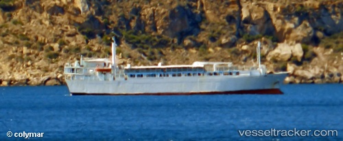
 Freedom
Current Status
Where is the vessel?
Freedom is currently in 25 nm E of Neapolis, based on AIS data received about 15h ago.
Latest AIS update:
Current position: 36.52642° N, 23.58912° E (25 nm E of Neapolis)
Average speed (last 7 days): Loading…
Average speed (last 30 days): Loading…
Vessel profile: Freedom is a Livestock Carrier with dimensions 87m x 16m.
This page combines live AIS, route history, probable destination signals, nearby traffic, and port activity for practical vessel monitoring.
The current position of vessel Freedom is 36.52642 lat / 23.58912 lng. Updated: 2026-05-17 19:33:28 UTCNearest reference points:
- 20 nm E of FOKIANOS
- 17 nm W of Milos (Adamas)
- Near Kythira
Currently sailing under the flag of Lebanon ![]()
Freedom built in 1971 year
Deadweight:
2794 tDetails:
Live Vessel Freedom Analytics (details, animations, etc.)
Recent AIS points (UTC):
2026-05-17 16:57:17 UTC · 36.97654, 23.71286 · SOG 10.7 kn · COG 185°2026-05-17 17:54:57 UTC · 36.80434, 23.69538 · SOG 10.7 kn · COG 182°
2026-05-17 19:10:28 UTC · 36.58988, 23.62230 · SOG 10.6 kn · COG 201°
2026-05-17 19:33:28 UTC · 36.52642, 23.58912 · SOG 10.8 kn · COG 200°