 vesseltracker.com
 Haci Mehmet Kaptan
Current Status
Where is the vessel?
Haci Mehmet Kaptan is currently in Near PENDIK, based on AIS data received less than 1h ago.
Latest AIS update:
Current position: 40.87394° N, 29.19352° E (Near PENDIK)
Average speed (last 7 days): Loading…
Average speed (last 30 days): Loading…
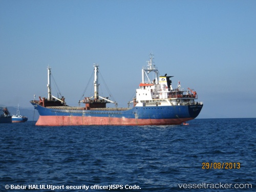
Vessel profile: Haci Mehmet Kaptan is a General Cargo Ship with dimensions 83m x 13m.
This page combines live AIS, route history, probable destination signals, nearby traffic, and port activity for practical vessel monitoring.
The current position of vessel Haci Mehmet Kaptan is 40.87394 lat / 29.19352 lng. Updated: 2026-04-29 07:18:20 UTCNearest reference points:
- Near PENDIK
- Near TUZLA
- Near Tuzla Free Zone
Currently sailing under the flag of Turkey ![]()
Haci Mehmet Kaptan built in 1984 year
Deadweight:
3270 tDetails:
Live Vessel Haci Mehmet Kaptan Analytics (details, animations, etc.)
Recent AIS points (UTC):
2026-04-29 04:09:21 UTC · 40.87377, 29.19338 · SOG 0 kn · COG 59°2026-04-29 04:33:19 UTC · 40.87406, 29.19336 · SOG 0 kn · COG 74°
2026-04-29 06:06:20 UTC · 40.87419, 29.19327 · SOG 0 kn · COG 80°
2026-04-29 07:18:20 UTC · 40.87394, 29.19352 · SOG 0.1 kn · COG 61°