 Rohav
Rohav
Current Status
Where is the vessel?
Rohav is currently in Near ENGENES, based on AIS data received about 16h ago.
Latest AIS update:
Current position: 68.85724° N, 17.09218° E (Near ENGENES)
Average speed (last 7 days): Loading…
Average speed (last 30 days): Loading…
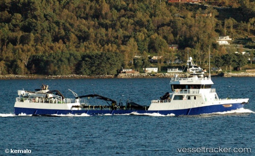
Vessel profile: Rohav is a Fish Carrier with dimensions 58m x 10m.
This page combines live AIS, route history, probable destination signals, nearby traffic, and port activity for practical vessel monitoring.
The current position of vessel Rohav is 68.85724 lat / 17.09218 lng. Updated: 2026-05-20 13:50:16 UTCNearest reference points:
- Near Skrolsvik
- Near Harstad
- Near SOMMAROY
Currently sailing under the flag of Norway ![]()
Rohav built in 2002 year
Deadweight:
650 tDetails:
Live Vessel Rohav Analytics (details, animations, etc.)
Recent AIS points (UTC):
2026-05-20 10:29:16 UTC · 68.79323, 17.18176 · SOG 9.5 kn · COG 348°2026-05-20 11:49:56 UTC · 68.85414, 17.07870 · SOG 0.3 kn · COG 311°
2026-05-20 13:26:16 UTC · 68.85539, 17.09220 · SOG 0.2 kn · COG 240°
2026-05-20 13:50:16 UTC · 68.85724, 17.09218 · SOG 0.3 kn · COG 152°