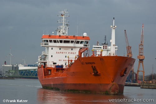
Key Marmara
Current StatusWhere is the vessel?
Key Marmara is currently in Near Alesund, based on AIS data received about 14h ago.
Latest AIS update:
Current position: 62.46421° N, 6.12104° E (Near Alesund)
Average speed (last 7 days): Loading…
Average speed (last 30 days): Loading…
Vessel profile: Key Marmara is a Chemical Oil Products Tanker with dimensions 17m x 105m.
This page combines live AIS, route history, probable destination signals, nearby traffic, and port activity for practical vessel monitoring.
The current position of vessel Key Marmara is 62.46421 lat / 6.12104 lng. Updated: 2026-06-09 23:26:52 UTCNearest reference points:
- Near Alesund
- Near Gjøsundet
- Near Fiskarstrand
Details:
Live Vessel Key Marmara Analytics (details, animations, etc.)
Recent AIS points (UTC):
2026-06-09 20:13:56 UTC · 62.49662, 5.39182 · SOG 13.2 kn · COG 79°2026-06-09 22:18:52 UTC · 62.46432, 6.12208 · SOG 0.7 kn · COG 267°
2026-06-09 22:23:34 UTC · 62.46424, 6.12108 · SOG 0.2 kn · COG 271°
2026-06-09 23:26:52 UTC · 62.46421, 6.12104 · SOG 0 kn · COG 271°