 vesseltracker.com
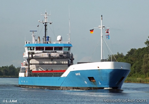
 Ankie
Ankie
Current Status
Where is the vessel?
Ankie is currently in 23 nm S of Eastbourne, based on AIS data received less than 1h ago.
Latest AIS update:
Current position: 50.38101° N, 0.23380° E (23 nm S of Eastbourne)
Average speed (last 7 days): Loading…
Average speed (last 30 days): Loading…
Vessel profile: Ankie is a Multi Purpose Carrier with dimensions 90m x 13m.
This page combines live AIS, route history, probable destination signals, nearby traffic, and port activity for practical vessel monitoring.
The current position of vessel Ankie is 50.38101 lat / 0.23380 lng. Updated: 2026-05-14 17:25:55 UTCNearest reference points:
- 27 nm S of Seaford
- 23 nm S of Poling
- Near Saint Leonards-on-Sea
Currently sailing under the flag of Netherlands ![]()
Ankie built in 2007 year
Deadweight:
3638 tDetails:
Live Vessel Ankie Analytics (details, animations, etc.)
Recent AIS points (UTC):
2026-05-14 14:05:26 UTC · 50.25570, -0.45290 · SOG 7 kn · COG 75°2026-05-14 15:40:35 UTC · 50.30977, -0.14450 · SOG 7.7 kn · COG 71°
2026-05-14 16:32:25 UTC · 50.34617, 0.03017 · SOG 8.5 kn · COG 71°
2026-05-14 17:25:55 UTC · 50.38101, 0.23380 · SOG 9.5 kn · COG 73°