 Asli Elif
Current Status
Where is the vessel?
Asli Elif is currently in Near Marina di Ravenna, based on AIS data received about 14h ago.
Latest AIS update:
Current position: 44.50873° N, 12.33509° E (Near Marina di Ravenna)
Average speed (last 7 days): Loading…
Average speed (last 30 days): Loading…
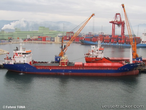
Vessel profile: Asli Elif is a General Cargo Ship with dimensions 89m x 13m.
This page combines live AIS, route history, probable destination signals, nearby traffic, and port activity for practical vessel monitoring.
The current position of vessel Asli Elif is 44.50873 lat / 12.33509 lng. Updated: 2026-05-22 11:39:09 UTCNearest reference points:
- Near Marina di Ravenna
- Near Porto San Vitale
- Near San Giuseppe
Currently sailing under the flag of Turkey ![]()
Asli Elif built in 2005 year
Deadweight:
3701 tDetails:
Live Vessel Asli Elif Analytics (details, animations, etc.)
Recent AIS points (UTC):
2026-05-22 08:12:03 UTC · 44.50840, 12.33693 · SOG 0 kn · COG 274°2026-05-22 09:24:04 UTC · 44.50784, 12.33618 · SOG 0.2 kn · COG 336°
2026-05-22 10:03:06 UTC · 44.50847, 12.33506 · SOG 0 kn · COG 95°
2026-05-22 11:39:09 UTC · 44.50873, 12.33509 · SOG 0 kn · COG 113°