 ROSE I
Current Status
Where is the vessel?
ROSE I is currently in Near Kamaterón, based on AIS data received about 15h ago.
Latest AIS update:
Current position: 37.89510° N, 23.53854° E (Near Kamaterón)
Average speed (last 7 days): Loading…
Average speed (last 30 days): Loading…
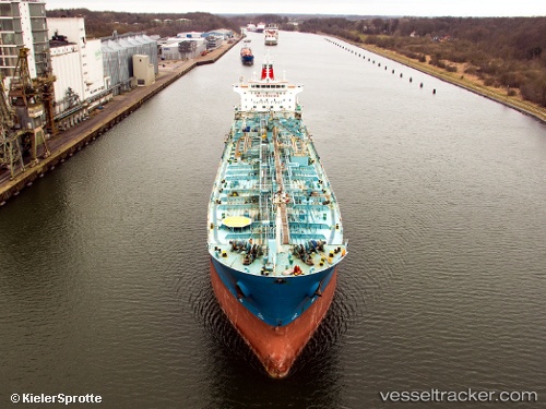
Vessel profile: ROSE I is a Chemical/Oil Products Tanker with dimensions 185m x 27m.
This page combines live AIS, route history, probable destination signals, nearby traffic, and port activity for practical vessel monitoring.
The current position of vessel ROSE I is 37.89510 lat / 23.53854 lng. Updated: 2026-05-20 19:30:20 UTCNearest reference points:
- Near PERAMA
- Near Drapetzona
- Near Keratsínion
Currently sailing under the flag of Liberia ![]()
ROSE I built in 2007 year
Deadweight:
37900 tDetails:
Live Vessel ROSE I Analytics (details, animations, etc.)
Recent AIS points (UTC):
2026-05-20 15:54:21 UTC · 37.89422, 23.53582 · SOG 0.2 kn · COG 29°2026-05-20 16:12:17 UTC · 37.89398, 23.53646 · SOG 0.1 kn · COG 1°
2026-05-20 18:02:24 UTC · 37.89415, 23.53730 · SOG 0.1 kn · COG 339°
2026-05-20 19:30:20 UTC · 37.89510, 23.53854 · SOG 0 kn · COG 287°