 Lingeborg
Current Status
Where is the vessel?
Lingeborg is currently in 33 nm S of Ferring, based on AIS data received about 14h ago.
Latest AIS update:
Current position: 50.25098° N, 0.31616° W (33 nm S of Ferring)
Average speed (last 7 days): Loading…
Average speed (last 30 days): Loading…
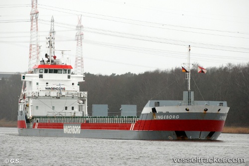
Vessel profile: Lingeborg is a Multi Purpose Carrier with dimensions 123m x 14m.
This page combines live AIS, route history, probable destination signals, nearby traffic, and port activity for practical vessel monitoring.
The current position of vessel Lingeborg is 50.25098 lat / -0.31616 lng. Updated: 2026-05-20 16:04:40 UTCNearest reference points:
- 23 nm S of Ferring
- 27 nm S of Seaford
- 15 nm S of Selsey
Currently sailing under the flag of Netherlands ![]()
Lingeborg built in 2007 year
Deadweight:
7350 tDetails:
Live Vessel Lingeborg Analytics (details, animations, etc.)
Recent AIS points (UTC):
2026-05-20 11:41:30 UTC · 50.06141, -1.39015 · SOG 12.5 kn · COG 72°2026-05-20 13:22:22 UTC · 50.14898, -0.90442 · SOG 10 kn · COG 75°
2026-05-20 13:38:20 UTC · 50.16025, -0.83725 · SOG 10 kn · COG 76°
2026-05-20 16:04:40 UTC · 50.25098, -0.31616 · SOG 7.8 kn · COG 77°