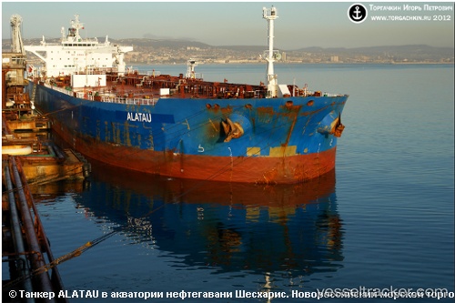
 Alatau
Current Status
Where is the vessel?
Alatau is currently in Near Myskhako, based on AIS data received about 14h ago.
Latest AIS update:
Current position: 44.60635° N, 37.82755° E (Near Myskhako)
Average speed (last 7 days): Loading…
Average speed (last 30 days): Loading…
Vessel profile: Alatau is a Crude Oil Tanker with dimensions 250m x 44m.
This page combines live AIS, route history, probable destination signals, nearby traffic, and port activity for practical vessel monitoring.
The current position of vessel Alatau is 44.60635 lat / 37.82755 lng. Updated: 2026-05-20 13:28:53 UTCNearest reference points:
- Near GELENDZHIK
- Near Novorossiysk
- Near Cpc Terminal
Currently sailing under the flag of Marshall Is ![]()
Alatau built in 2009 year
Deadweight:
115949 tDetails:
Live Vessel Alatau Analytics (details, animations, etc.)
Recent AIS points (UTC):
2026-05-20 02:46:36 UTC · 44.68806, 37.59112 · SOG 9.3 kn · COG 94°2026-05-20 02:46:36 UTC · 44.68806, 37.59112 · SOG 9.3 kn · COG 94°
2026-05-20 12:56:23 UTC · 44.69111, 37.59214 · SOG 10.7 kn · COG 69°
2026-05-20 13:28:53 UTC · 44.60635, 37.82755 · SOG 16.4 kn · COG 86°