 vesseltracker.com
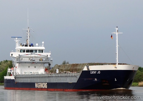
 CATHY JO
Current Status
Where is the vessel?
CATHY JO is currently in 50 nm N of Villanueva de Lorenzana, based on AIS data received less than 1h ago.
Latest AIS update:
Current position: 44.26833° N, 8.99833° W (50 nm N of Villanueva de Lorenzana)
Average speed (last 7 days): Loading…
Average speed (last 30 days): Loading…
Vessel profile: CATHY JO is a General Cargo Ship with dimensions 111m x 14m.
This page combines live AIS, route history, probable destination signals, nearby traffic, and port activity for practical vessel monitoring.
The current position of vessel CATHY JO is 44.26833 lat / -8.99833 lng. Updated: 2026-05-14 06:08:14 UTCNearest reference points:
- 30 nm NW of Meiras-Valdoviño
- 13 nm NE of Villanueva de Lorenzana
- 15 nm NW of CEDEIRA
Currently sailing under the flag of Netherlands ![]()
CATHY JO built in 2008 year
Deadweight:
6000 tDetails:
Live Vessel CATHY JO Analytics (details, animations, etc.)
Recent AIS points (UTC):
2026-05-14 01:51:30 UTC · 43.82120, -9.31015 · SOG 7.9 kn · COG 27°2026-05-14 03:23:29 UTC · 43.98909, -9.20029 · SOG 6.9 kn · COG 22°
2026-05-14 04:12:49 UTC · 44.07435, -9.13975 · SOG 7 kn · COG 23°
2026-05-14 06:08:14 UTC · 44.26833, -8.99833 · SOG 6 kn · COG -1°