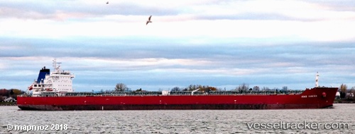
 Unity N
Current Status
Where is the vessel?
Unity N is currently in 142 nm SE of Port Saint John's, based on AIS data received about 14h ago.
Latest AIS update:
Current position: 33.47628° S, 31.28723° E (142 nm SE of Port Saint John's)
Average speed (last 7 days): Loading…
Average speed (last 30 days): Loading…
Vessel profile: Unity N is a Bulk Carrier with dimensions 229m x 32m.
This page combines live AIS, route history, probable destination signals, nearby traffic, and port activity for practical vessel monitoring.
The current position of vessel Unity N is -33.47628 lat / 31.28723 lng. Updated: 2026-06-11 01:07:33 UTCNearest reference points:
- 125 nm SE of Port Edward
- 23 nm E of Port Saint John's
- 181 nm SE of Hibberdene
Currently sailing under the flag of Marshall Is ![]()
Unity N built in 2011 year
Deadweight:
79642 tDetails:
Live Vessel Unity N Analytics (details, animations, etc.)
Recent AIS points (UTC):
2026-06-10 22:36:43 UTC · -33.66294, 30.84364 · SOG 9.5 kn · COG 54°2026-06-10 22:36:43 UTC · -33.66294, 30.84364 · SOG 9.5 kn · COG 54°
2026-06-10 22:36:43 UTC · -33.66294, 30.84364 · SOG 9.5 kn · COG 54°
2026-06-11 01:07:33 UTC · -33.47628, 31.28723 · SOG 10.2 kn · COG 55°