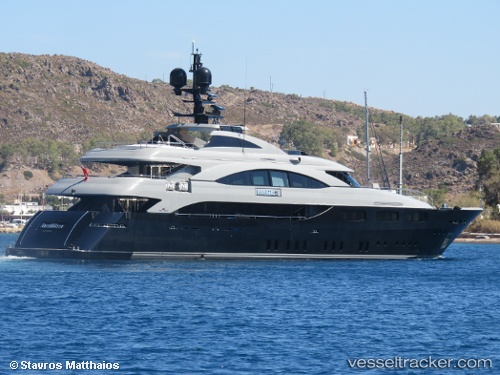
 Belita
Current Status
Where is the vessel?
Belita is currently in Near Vouliagméni, based on AIS data received about 15h ago.
Latest AIS update:
Current position: 37.80400° N, 23.77544° E (Near Vouliagméni)
Average speed (last 7 days): Loading…
Average speed (last 30 days): Loading…
Vessel profile: Belita is a Service Ship with dimensions 50m x 50m.
This page combines live AIS, route history, probable destination signals, nearby traffic, and port activity for practical vessel monitoring.
The current position of vessel Belita is 37.80400 lat / 23.77544 lng. Updated: 2026-05-20 08:15:23 UTCNearest reference points:
- Near Vouliagméni
- Near ALIMOS
- Near FLISVOS
Currently sailing under the flag of Malta ![]()
Details:
Live Vessel Belita Analytics (details, animations, etc.)
Recent AIS points (UTC):
2026-05-20 04:27:36 UTC · 37.80397, 23.77542 · SOG 0 kn · COG 34°2026-05-20 05:44:45 UTC · 37.80399, 23.77541 · SOG 0 kn · COG 34°
2026-05-20 07:36:36 UTC · 37.80400, 23.77543 · SOG 0 kn · COG 34°
2026-05-20 08:15:23 UTC · 37.80400, 23.77544 · SOG 0 kn · COG 34°