 AGIOS NIKOLAOS
Current Status
Where is the vessel?
AGIOS NIKOLAOS is currently in 69 nm SW of Utiel, based on AIS data received about 14h ago.
Latest AIS update:
Current position: 38.61333° N, 11.99833° W (69 nm SW of Utiel)
Average speed (last 7 days): Loading…
Average speed (last 30 days): Loading…
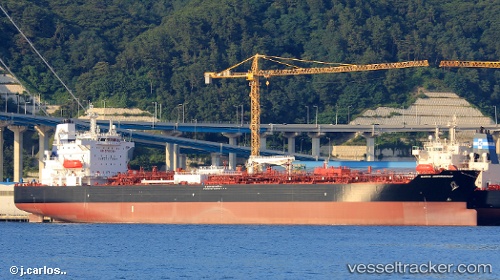
Vessel profile: AGIOS NIKOLAOS is a Chemical/Oil Products Tanker with dimensions 183m x 183m.
This page combines live AIS, route history, probable destination signals, nearby traffic, and port activity for practical vessel monitoring.
The current position of vessel AGIOS NIKOLAOS is 38.61333 lat / -11.99833 lng. Updated: 2026-05-20 11:38:41 UTCNearest reference points:
- 92 nm SW of Utiel
- 94 nm W of Los Ramos
- 95 nm W of Los Ramos
Currently sailing under the flag of Marshall Islands ![]()
AGIOS NIKOLAOS built in 2018 year
Deadweight:
49988 tDetails:
Live Vessel AGIOS NIKOLAOS Analytics (details, animations, etc.)
Recent AIS points (UTC):
2026-05-20 07:22:43 UTC · 37.78522, -12.21735 · SOG 11.3 kn · COG 7°2026-05-20 09:47:54 UTC · 38.25245, -12.10343 · SOG 11.6 kn · COG 14°
2026-05-20 10:27:22 UTC · 38.37942, -12.06603 · SOG 12 kn · COG 12°
2026-05-20 11:38:41 UTC · 38.61333, -11.99833 · SOG 12 kn · COG -1°