 vesseltracker.com
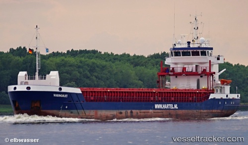
 Haringvliet
Current Status
Where is the vessel?
Haringvliet is currently in 34 nm SW of Kirkehamn, based on AIS data received less than 1h ago.
Latest AIS update:
Current position: 57.81348° N, 5.83432° E (34 nm SW of Kirkehamn)
Average speed (last 7 days): Loading…
Average speed (last 30 days): Loading…
Vessel profile: Haringvliet is a General Cargo Ship with dimensions 89m x 13m.
This page combines live AIS, route history, probable destination signals, nearby traffic, and port activity for practical vessel monitoring.
The current position of vessel Haringvliet is 57.81348 lat / 5.83432 lng. Updated: 2026-05-15 16:39:04 UTCNearest reference points:
- Near Egersund
- Near Åna-Sira
- Near Kirkehamn
Currently sailing under the flag of Netherlands ![]()
Haringvliet built in 2012 year
Deadweight:
3850 tDetails:
Live Vessel Haringvliet Analytics (details, animations, etc.)
Recent AIS points (UTC):
2026-05-15 13:08:25 UTC · 57.91577, 4.84544 · SOG 8.5 kn · COG 100°2026-05-15 13:28:55 UTC · 57.90588, 4.93823 · SOG 9 kn · COG 105°
2026-05-15 15:33:08 UTC · 57.84543, 5.51931 · SOG 9.7 kn · COG 111°
2026-05-15 16:39:04 UTC · 57.81348, 5.83432 · SOG 9.4 kn · COG 98°