 MSC OLGA F
Current Status
Where is the vessel?
MSC OLGA F is currently in 13 nm SW of Paphos, based on AIS data received about 14h ago.
Latest AIS update:
Current position: 34.57110° N, 32.26967° E (13 nm SW of Paphos)
Average speed (last 7 days): Loading…
Average speed (last 30 days): Loading…
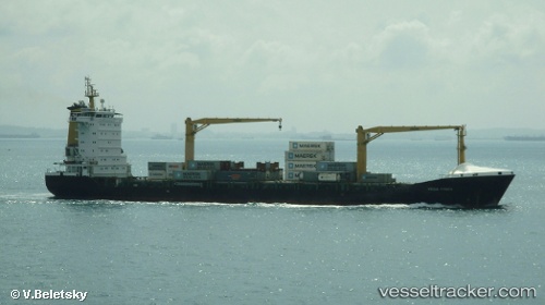
Vessel profile: MSC OLGA F is a Container Ship with dimensions 23m x 148m.
This page combines live AIS, route history, probable destination signals, nearby traffic, and port activity for practical vessel monitoring.
The current position of vessel MSC OLGA F is 34.57110 lat / 32.26967 lng. Updated: 2026-05-20 15:55:28 UTCNearest reference points:
- 11 nm SE of Paphos
- Near Limassol
- 68 nm SW of Paphos
Currently sailing under the flag of Liberia ![]()
MSC OLGA F built in 2006 year
Deadweight:
13775 tDetails:
Live Vessel MSC OLGA F Analytics (details, animations, etc.)
Recent AIS points (UTC):
2026-05-20 11:36:08 UTC · 34.63491, 31.84820 · SOG 4.8 kn · COG 111°2026-05-20 13:05:07 UTC · 34.60971, 31.99696 · SOG 5.1 kn · COG 102°
2026-05-20 13:50:18 UTC · 34.59784, 32.07126 · SOG 5 kn · COG 101°
2026-05-20 15:55:28 UTC · 34.57110, 32.26967 · SOG 4.7 kn · COG 98°